Defense Geospatial Information Agency "Division General Constantin Barozzi"
Ministry of National Defense


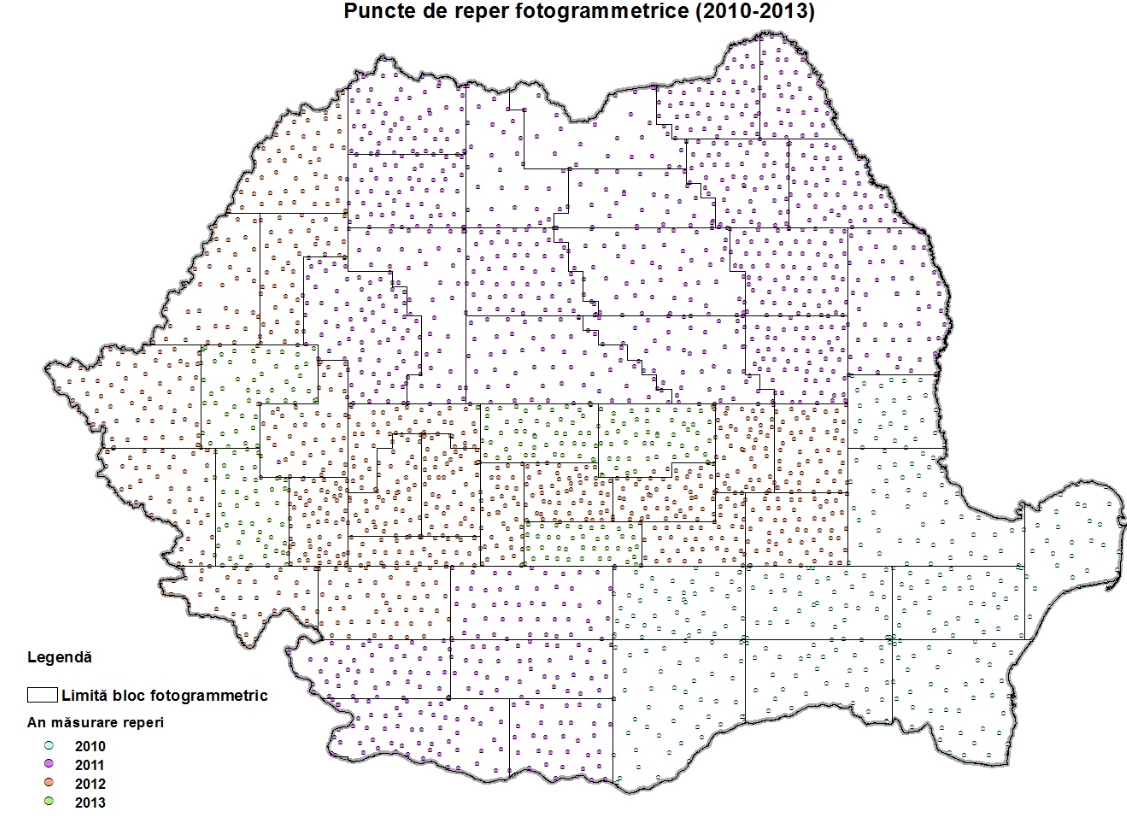
Photogrammetric landmarks
Map type: Vector dataProduct name: Photogrammetric landmarks (2010-2013)

Technical details
The coordinate system in which they were created: Coordinate system S42
Projection: Stereo projection 1970
Planimetric accuracy: 20
Altimetric/Planimetric accuracy: 20
13
Maximum file size (MB)
2741
Number of points
20
Planimetric accuracy (cm), under
Attribute table description
The attribute table contains the following fields:
| # | Field name | Description |
|---|---|---|
| 1 | Nr_crt | current number |
| 2 | Den_r_b | the current number of the landmark within the block |
| 3 | Den_bloc | the name of the block |
| 4 | Den_r | the name of the landmark |
| 5 | B_ETRS89g | the latitude of the landmark in the ETRS89 system expressed in degrees and fractions of degrees |
| 6 | L_ETRE89g | the longitude of the landmark in the ETRS89 system expressed in degrees and fractions of degrees |
| 7 | H_ETRS89m | the ellipsoidal elevation of the landmark referenced to the GRS80 ellipsoid |
| 8 | H_EGM08m | the orthometric elevation of the landmark relative to the GRS80 ellipsoid calculated using the global geopotential model EGM2008 |
| 9 | RMS_Bsec | accuracy of latitude determination |
| 10 | RMS_Lsec | longitude determination precision |
| 11 | RMS_H08m | the precision of determining the ellipsoidal altitude |
| 12 | B_S42gfg | the latitude of the landmark in the 1942 coordinate system expressed in degrees and fractions of degrees |
| 13 | L_S42gfg | the longitude of the landmark in the 1942 coordinate system expressed in degrees and fractions of degrees |
| 14 | Nx_S42_S70 | the x-coordinate of the landmark in the 1942 coordinate system expressed in meters |
| 15 | Ey_S42_S70 | the y-coordinate of the landmark in the 1942 coordinate system expressed in meters |
| 16 | H_S42m | the ellipsoidal elevation of the landmark referred to the Krasovsky ellipsoid |
| 17 | H_MN75m | the normal elevation of the landmark relative to the Krasovsky ellipsoid calculated using the undulation of the quasi-hyggeoid |
| 18 | RMS_N_x_m | the precision of determining the x-coordinate of the landmark in the 1942 coordinate system expressed in meters |
| 19 | RMS_E_y_m | the precision of determining the y-coordinate of the landmark in the 1942 coordinate system expressed in meters |
| 20 | RMS_HMN75m | precizia de determinare a altitudinii normale a reperului referită la elipsoidul Krasovsky |
| 21 | Data | data în care s-a executat măsurătoarea exprimată astfel: aaaallzz (an-lună-zi) |
| 22 | Descriere | descrierea topografică a reperului |
| 23 | Observații | eventuale observaţii |
Description / Method of acquisition
The product was developed between 2010 and 2013 through measurements using geodetic GPS receivers.
The stages of production were as follows:
- Measuring reference points using the static method with geodetic GPS receivers (Trimble 4000SSi and Leica 1200) for 45 minutes, using the ROMPOS network as a support network with coordinates in the ETRS89 system.
- Downloading data using Trimble GPSurvey 2.35 and Leica Geo Office Combined 4.0 applications.
- Processing GPS observations using GPSurvey 2.35 and Leica Geo Office Tools 4.0 applications.
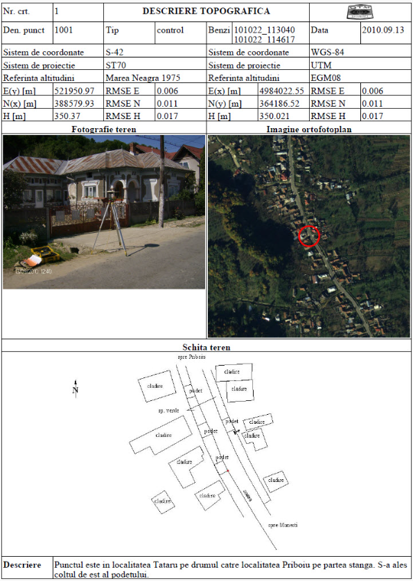
- Creating topographic descriptions of reference points, including:
- The measured point's coordinates in the S42 and WGS84 coordinate systems.
- A field photograph.
- Position on the orthophoto image.
- A field-drawn sketch.
- Description of access to the point.
- Transforming and converting coordinates from the ETRS89 coordinate system to the S42 coordinate system using the Transdat 4.0 application.
- Conducting a technical quality control check.
Dataset
Index
Download Index Landmarks [pdf]